On
Board
Narrowboat "FRILFORD"
(British Waterways No. 500645)
CHAPTER
FOURTEEN - "Big Barges, River Passage and Rain"
5th - 6th July
2005
The day broke grey and damp. An impressive and angry skyscape contrasted
and complimented the ordinary and distinctly unimpressive landscape
all around. The River Aire, however, continued as an attractive, if
blighted, waterway, with deep smooth water passing between attractively
wooded banks and under a variety of old and new bridges.  There
are signs of commercial river traffic everywhere and I passed a wharf
where two large barges, with attendant tugs, were being loaded by
crane. What they were loading I am not quite sure, but I was quite
glad to see them alongside and not navigating against me. There
are signs of commercial river traffic everywhere and I passed a wharf
where two large barges, with attendant tugs, were being loaded by
crane. What they were loading I am not quite sure, but I was quite
glad to see them alongside and not navigating against me.
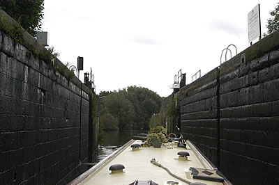
Very soon I was
approaching Woodnook Lock. It’s big and imposing, but in a different
way to the ones I’d come through the day before. It seemed older,
although in fact it replaced two much older locks, Fairies and Altoft
Locks, so I don’t know how old it is really. Anyway, as I was
standing on top of it a cruiser approached from the other way. I opened
the gates for her and locked her up. There were two people on board
and one spoke to me. “Will you be okay?” he asked, “given
that you’re on your own.” I thanked him and told him I’d
be fine. In reality I was only okay! The lock is deep – 13’
6” apparently. The operation is electro-hydraulic so there is
no problem with that and since it works itself once the operation
has started, I was able to tend to FRILFORD. We were going down so
I had to keep lengthening her lines as the water dropped. When it
finished dropping, FRILFORD seemed a long way down. The lock ladder
next to FRILFORD was rather rickety and had a faded notice tied to
it. I could not read the notice but I’ve seen its like before.
 What
they say is ‘Don’t use this ladder’ but I had no
choice for I could not move FRILFORD to another ladder as I could
not control her from the lock side. Had I realised I’d’ve
moored her somewhere else, but the ladder was all but underwater when
I first came into the lock! I am always keen to have contact with
one of FRILFORD’s mooring ropes when she is in a lock, so I
can get to her when I need to. Given that I had to climb down the
rickety, and slimy green, ladder I wanted to throw FRILFORD’s
centre line down onto her roof, so I’d be free to climb down,
but then I’d have no control over her and since she was in a
big lock, the bottom gates of which were now open there was scope
that she’d drift out of the lock and off down the river. I know
that sounds daft but this lock, on top of everything else, leaked
rather. The top gates might have been closed and the paddles down
but there was a considerable amount of water cascading through the
gates creating a significant flow in the lock. By the time I got down
to FRILFORD she would be, and was, making her own way out towards
the river. I tucked the centre line in the back of my trousers and
made it down the ladder to FRILFORD’s roof. I looked up. Dark,
slimy, dripping walls were all around. I could have been in some sort
of topless Tolkienesque catacomb. I motored FRILFORD out into the
river, tied her up on the layby pontoon, went back, closed the lock,
as required, got back on board FRILFORD, took a deep breath and set
off once again. According to my logbook Woodnook Lock had been my
440th lock since I set off for Lechlade back in February. Most of
them I’d done myself, without problem. I’d just done Woodnook
Lock without any actually problem, but there was something about the
place I did not like, and I was pleased to get going again. It just
goes to show, as one is shown all the time when navigating on a boat,
wherever one is, river, canal, open sea, that one can never take anything
for granted. I wonder if that lock’s haunted?! What
they say is ‘Don’t use this ladder’ but I had no
choice for I could not move FRILFORD to another ladder as I could
not control her from the lock side. Had I realised I’d’ve
moored her somewhere else, but the ladder was all but underwater when
I first came into the lock! I am always keen to have contact with
one of FRILFORD’s mooring ropes when she is in a lock, so I
can get to her when I need to. Given that I had to climb down the
rickety, and slimy green, ladder I wanted to throw FRILFORD’s
centre line down onto her roof, so I’d be free to climb down,
but then I’d have no control over her and since she was in a
big lock, the bottom gates of which were now open there was scope
that she’d drift out of the lock and off down the river. I know
that sounds daft but this lock, on top of everything else, leaked
rather. The top gates might have been closed and the paddles down
but there was a considerable amount of water cascading through the
gates creating a significant flow in the lock. By the time I got down
to FRILFORD she would be, and was, making her own way out towards
the river. I tucked the centre line in the back of my trousers and
made it down the ladder to FRILFORD’s roof. I looked up. Dark,
slimy, dripping walls were all around. I could have been in some sort
of topless Tolkienesque catacomb. I motored FRILFORD out into the
river, tied her up on the layby pontoon, went back, closed the lock,
as required, got back on board FRILFORD, took a deep breath and set
off once again. According to my logbook Woodnook Lock had been my
440th lock since I set off for Lechlade back in February. Most of
them I’d done myself, without problem. I’d just done Woodnook
Lock without any actually problem, but there was something about the
place I did not like, and I was pleased to get going again. It just
goes to show, as one is shown all the time when navigating on a boat,
wherever one is, river, canal, open sea, that one can never take anything
for granted. I wonder if that lock’s haunted?!
The immediate
approach to Castleford from the south-west is deceptive. Either side
of the river appears more countrified than of late, although, in fact,
it is passing through areas of increasing industrialisation. Then
suddenly the river appears to stop at a large building atop a wall. In reality one has arrived at a major water crossroads which has to
be negotiated with care. The now ubiquitous traffic lights are much
in evidence, showing Amber again in this instance. The Nicholson’s
guide is a bit frustrating at this point as its descriptions of the
navigation are given as if one is coming from the north to this junction,
from Leeds, so warnings about which way not to turn have to be reinterpreted
if, like me, one is coming from the south-west. Actually this happens
a lot and I have to curb my frustrations. The Nicholson guides are
very good indeed and they cannot, of course, be expected to write
them with every direction of travel catered for. All the information
one could want is therein, but when they are describing a passage
from east to west and one is travelling from west to east, one constantly
has to read forward then interpolate the text to make it fit one’s
own navigation. Hence when Nicolson says, as it does, ‘There
is a waterways crossroads at Castleford. Navigators heading towards
Sowerby Bridge should turn right here and must on no account go straight
across – since that way leads to the Castleford Weir’
I had to be aware that I was coming from the Sowerby Bridge direction
and that if I were to turn right at the crossroads I’d be heading
straight for that self-same huge Castleford Weir! What I wanted to
do was to go straight on: exactly the thing warned against in the
guide, as written. This is no criticism at all. Nicholson guides also
contain comprehensive maps and even the most cartographically-challenged
can see the direction in which they have to go. I do have to watch
myself, however. Later on, much later on when entering Manchester
in company with another boat, when I had my cousin’s son Jonathan
on board as crew, I managed to make myself look really very foolish
by misreading the chart, albeit the fiddly bit which describes the
basin in Manchester, and started to work a lock which, it transpired,
was the first of thirteen locks through Manchester from which there
was no respite or chance to turn round, and which it was not necessary
to go through to moor in the basin. Luckily the person on the other
boat was kind and friendly in her confused questioning of my navigation
failure!
In reality one has arrived at a major water crossroads which has to
be negotiated with care. The now ubiquitous traffic lights are much
in evidence, showing Amber again in this instance. The Nicholson’s
guide is a bit frustrating at this point as its descriptions of the
navigation are given as if one is coming from the north to this junction,
from Leeds, so warnings about which way not to turn have to be reinterpreted
if, like me, one is coming from the south-west. Actually this happens
a lot and I have to curb my frustrations. The Nicholson guides are
very good indeed and they cannot, of course, be expected to write
them with every direction of travel catered for. All the information
one could want is therein, but when they are describing a passage
from east to west and one is travelling from west to east, one constantly
has to read forward then interpolate the text to make it fit one’s
own navigation. Hence when Nicolson says, as it does, ‘There
is a waterways crossroads at Castleford. Navigators heading towards
Sowerby Bridge should turn right here and must on no account go straight
across – since that way leads to the Castleford Weir’
I had to be aware that I was coming from the Sowerby Bridge direction
and that if I were to turn right at the crossroads I’d be heading
straight for that self-same huge Castleford Weir! What I wanted to
do was to go straight on: exactly the thing warned against in the
guide, as written. This is no criticism at all. Nicholson guides also
contain comprehensive maps and even the most cartographically-challenged
can see the direction in which they have to go. I do have to watch
myself, however. Later on, much later on when entering Manchester
in company with another boat, when I had my cousin’s son Jonathan
on board as crew, I managed to make myself look really very foolish
by misreading the chart, albeit the fiddly bit which describes the
basin in Manchester, and started to work a lock which, it transpired,
was the first of thirteen locks through Manchester from which there
was no respite or chance to turn round, and which it was not necessary
to go through to moor in the basin. Luckily the person on the other
boat was kind and friendly in her confused questioning of my navigation
failure!
 Anyway,
I negotiated the crossroads without incident, passing another Amber
traffic light as I did so, passed through the large flood lock and
into the basin at Castleford. There is a large British Waterways office
and facility at Castleford, and I wanted to go in and make my number
with them. And buy some pump-out tickets so I could pump out at the
sanitary station there. First I had to moor however, and there were
already a number of boats tied up along the rather short wall provided
for such purpose. I motored slowly past them wondering if there was
another place to tie up but realised there was not. A couple of narrowboats
were coming the other way and I paused waiting for them to pass whilst
I considered my next move. Pausing and my next move were getting tricky,
however. The wind was blowing quite hard and a narrowboat cannot cope
with being stopped in the water when the wind is blowing. Very easily
the bows can be blown off and there is little one can do to regain
them. I’d come to realise that the short wall on the starboard
side was indeed the mooring for this basin and that there was only
one space along it, which was behind me. Was I really going to reverse
FRILFORD, across the wind and in front of there various people who
were milling about? Yes, apparently I was! Anyway,
I negotiated the crossroads without incident, passing another Amber
traffic light as I did so, passed through the large flood lock and
into the basin at Castleford. There is a large British Waterways office
and facility at Castleford, and I wanted to go in and make my number
with them. And buy some pump-out tickets so I could pump out at the
sanitary station there. First I had to moor however, and there were
already a number of boats tied up along the rather short wall provided
for such purpose. I motored slowly past them wondering if there was
another place to tie up but realised there was not. A couple of narrowboats
were coming the other way and I paused waiting for them to pass whilst
I considered my next move. Pausing and my next move were getting tricky,
however. The wind was blowing quite hard and a narrowboat cannot cope
with being stopped in the water when the wind is blowing. Very easily
the bows can be blown off and there is little one can do to regain
them. I’d come to realise that the short wall on the starboard
side was indeed the mooring for this basin and that there was only
one space along it, which was behind me. Was I really going to reverse
FRILFORD, across the wind and in front of there various people who
were milling about? Yes, apparently I was!
 In
the event it went rather well. The wind abated for a few minutes and
what there was of it seemed to be helping me rather than hindering.
Trying to look nonchalant I reversed across the basin towards the
space. As I approached it I realised why the space was there. It was
the mooring for the sanitary station and was limited to thirty minutes.
Fine; that was exactly what I wanted! FRILFORD came alongside nicely
and an elderly gentleman, who’d been watching me from his own
small narrowboat, suddenly walked along and offered to take my lines.
I think he wanted to see that I could get in before offering to help.
I went into the British Waterways office and had a very nice chat
with a young woman who was as helpful as she could be, given that
she appeared to know nothing. “It’s my first week,”
she explained, “I hope you can bear with me.” I could;
she was charming and brightened up what was otherwise rather a grey
day. Armed with a handful of cards I got FRILFORD pumped out just
as the rain started to fall. At the same time various boats left,
and what had been a crowded wall suddenly had plenty of space. Is
my pumping out such a ghastly experience? In
the event it went rather well. The wind abated for a few minutes and
what there was of it seemed to be helping me rather than hindering.
Trying to look nonchalant I reversed across the basin towards the
space. As I approached it I realised why the space was there. It was
the mooring for the sanitary station and was limited to thirty minutes.
Fine; that was exactly what I wanted! FRILFORD came alongside nicely
and an elderly gentleman, who’d been watching me from his own
small narrowboat, suddenly walked along and offered to take my lines.
I think he wanted to see that I could get in before offering to help.
I went into the British Waterways office and had a very nice chat
with a young woman who was as helpful as she could be, given that
she appeared to know nothing. “It’s my first week,”
she explained, “I hope you can bear with me.” I could;
she was charming and brightened up what was otherwise rather a grey
day. Armed with a handful of cards I got FRILFORD pumped out just
as the rain started to fall. At the same time various boats left,
and what had been a crowded wall suddenly had plenty of space. Is
my pumping out such a ghastly experience?
I opted to have
a bit of lunch, unusual for me, and wait for the rain to stop. I rather
wondered where the commercial traffic was. Nicholson talks of the
need to moor securely to avoid being banged about by the wash of passing
commercial traffic, but where was it? 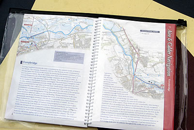 It
appeared moments later. In quick succession two self-propelled barges
passed through the basin and the flood lock, one in each direction.
They were big and filled the flood lock as they passed through it.
Now I knew what we were dealing with. Later a couple of tugs passed
by. How lucky I had been that this lot had not been around when I
was doing my reversing manoeuvre! It
appeared moments later. In quick succession two self-propelled barges
passed through the basin and the flood lock, one in each direction.
They were big and filled the flood lock as they passed through it.
Now I knew what we were dealing with. Later a couple of tugs passed
by. How lucky I had been that this lot had not been around when I
was doing my reversing manoeuvre!
Later it stopped
raining and I got going. The canal at Castleford is dominated by the
Hickson and Welch chemical works. Founded in 1905 by a Mr. Hickson
the company is now a multinational giant best known in the UK for
developing the pressure treatment process used to preserve timber.
How do I know this? Nicholson’s guide… I slipped past
Hickson and Welch and into Bulholme Lock. Another huge electro-hydraulic
lock, but you get the idea now; we are in commercial country. Wither
the cranky old stone-lined holes that pass for locks in places on
the Huddersfield Narrow Canal?! I did not know it at the time, although
I suspected it, but Bulholme Lock represented something of a gateway
for me and FRILFORD. Aside from the short refuge which is the Selby
Canal, nothing the other side of it was anything like I’d experienced
before. All would be different until I passed back through it en route
to Leeds – which I would do some weeks later.
 Below
Bulholme Lock one is navigating on the River Aire. It is quite an
experience. The river winds its way through land blighted by mining
which, in recent years, has been turned, very successfully, into a
series of large nature reserves. Not that one can see anything from
the river. The banks are quite steep and, in the most part, heavily
wooded. There is absolutely nowhere to moor. Were my engine to fail,
and I only learned some time later how easily it might have done,
given what was happening down below – nothing too serious in
itself but something that would have caused the engine to be U/S!,
I would have had to drift down river hoping to pick up a mooring somewhere
near the power station. Or I could have dropped my anchor and hung
around out there, literally, waiting for help to come. Anyway –
the engine did not fail and FRILFORD pushed on easily towards Ferrybridge.
The river was wide, deep and dark reflecting the glowering clouds
which hung around threateningly. In no time at all it was raining
again and I put FRILFORD in neutral to drift for a moment whilst I
nipped down below to get into my foul weather gear. Having sailed
around the world, including through the Southern Ocean, I have, still
have that is, all the right kit. I have a newer and better set at
home but on this trip I am deliberately wearing my foul weather kit
from the British Steel Challenge of 1992-93. Those dark stains around
the hood and in the back of the neck are genuine salt stains from
58 degrees south – iceberg country. I was soon cocooned in yellow
and safe from the wet. Mind you, it is a bit miserable when the rain
pours down, but there we are! Below
Bulholme Lock one is navigating on the River Aire. It is quite an
experience. The river winds its way through land blighted by mining
which, in recent years, has been turned, very successfully, into a
series of large nature reserves. Not that one can see anything from
the river. The banks are quite steep and, in the most part, heavily
wooded. There is absolutely nowhere to moor. Were my engine to fail,
and I only learned some time later how easily it might have done,
given what was happening down below – nothing too serious in
itself but something that would have caused the engine to be U/S!,
I would have had to drift down river hoping to pick up a mooring somewhere
near the power station. Or I could have dropped my anchor and hung
around out there, literally, waiting for help to come. Anyway –
the engine did not fail and FRILFORD pushed on easily towards Ferrybridge.
The river was wide, deep and dark reflecting the glowering clouds
which hung around threateningly. In no time at all it was raining
again and I put FRILFORD in neutral to drift for a moment whilst I
nipped down below to get into my foul weather gear. Having sailed
around the world, including through the Southern Ocean, I have, still
have that is, all the right kit. I have a newer and better set at
home but on this trip I am deliberately wearing my foul weather kit
from the British Steel Challenge of 1992-93. Those dark stains around
the hood and in the back of the neck are genuine salt stains from
58 degrees south – iceberg country. I was soon cocooned in yellow
and safe from the wet. Mind you, it is a bit miserable when the rain
pours down, but there we are!
In describing
the river and surrounding area I shall quote from the Nicholson guide
which, as usual, seems to have got the place just right. It describes
how landscaping of the now-abandoned Fryston and Whelden colleries
is still being undertaken. The lower land to the north of the river
form the ‘Ings’, a word dating back to Viking times which
denotes areas of riverside water meadows which are subject to seasonal
flooding. Nicholson points out that mining subsidence in the area,
particularly over the last 50 years, has meant that much of the land
is permanently waterlogged, resulting in the loss of a considerable
amount of agricultural land. However, these wetlands have provided
a habitat for all forms of wildlife. The area to the north of the
river to the village of Fairburn, now known as the Fairburn Ings Nature
Reserve, has been recognised as a reserve since 1957 and became a
statutory bird sanctuary in 1968. Some 251 species of bird have been
recorded, of which some 170 are regular visitors.  The
land was originally acquired to provide space for the tipping of spoil
from the collieries and whilst the Coal Authority still has tipping
rights in the area it has restricted its activities in the interest
of the wildlife. The
land was originally acquired to provide space for the tipping of spoil
from the collieries and whilst the Coal Authority still has tipping
rights in the area it has restricted its activities in the interest
of the wildlife.
I didn’t
see much on the river that day. A couple of narrowboats passed me
going in the other direction as did a big residential Dutch Barge
and, later, a cruiser made a significant detour over to my position
to yell at me that there was a large tanker at the Ferrybridge Flood
Lock and to look out! I yelled back my thanks as my brow knitted in
concern. I had picked up a pamphlet at the BW office in Castleford
about the need to give way to commercial traffic and had seen the
diagram of the Ferrybridge Flood Lock and where the ‘refuge’
area was for private vessels avoiding commercial vessels moving in
the area of the lock, but would it all make sense when I got there?
Being on one’s own one does not have the chance to mull these
things over with another and, me being me, I am capable of building
these things up in my mind somewhat. I say that but, actually, I usually
do what I imagine any sane person would do – proceed with caution
and be ready for anything. And react positively and early.
Passing Fairburn
Ings the river bank gives off a surprisingly rural feel, but this
changes immediately on the approach to Ferrybridge Power Station (two,
actually ‘A’ and ‘C’) which rises imposingly
ahead. The river passes under an enormous new road bridge, still under
construction as I passed, and then one is into the midst of a large
industrial complex.  Ferrybridge
Power Station is a 1,995MW coal fired power station in West Yorkshire
which was commissioned in 1966. In 2002, it was the first power station
in the UK to ‘co-fire’ fuels from renewable sources in
order to displace fossil fuels and it remains the market leader in
this field. It is described as a flexible, mid-merit station. Whatever
it is, its cooling towers overpower the surrounding countryside and
the river. Ferrybridge
Power Station is a 1,995MW coal fired power station in West Yorkshire
which was commissioned in 1966. In 2002, it was the first power station
in the UK to ‘co-fire’ fuels from renewable sources in
order to displace fossil fuels and it remains the market leader in
this field. It is described as a flexible, mid-merit station. Whatever
it is, its cooling towers overpower the surrounding countryside and
the river.
Around the corner,
past a small village church in the midst of newly-developed cottages
on the edge of Brotherton, a straight section takes one to a couple
of road bridges, one old one new, and beyond them is the Ferrybridge
Flood Lock. There was no sign of the large tanker I’d been warned
about, but the lock traffic light was on Red, not Amber, and clearly
I had to stop. I manoeuvred to the right hand arch of the old brick
bridge and stopped as best I could. The windy conditions and the river
stream made this a bit tricky but I was able to keep out of the way
as a large tank barge did indeed hove into view. It was really big!
I thought the barges I’d seen in Castleford were big, but this
was somewhat bigger. Not only that, it seemed to be moving quite fast
and accelerating, and its bows were pointing straight at me. By now
I was in quite shallow water and well to the side so I know it wasn’t
going to come anywhere near where I was, but it was quite a sight.
Then the helmsman put the wheel over and the barge turned starboard
and went through the central arch of the bridge. Its engine thumped,
a large ‘rooster tail’ of wash came off its propeller
as it was gone! I waited another couple of minutes and the traffic
light turned to Green. Not Amber but Green – I had right of
way! I set off and within moments was in the heart of the flood lock
exchanging friendly waves with the female lockkeeper in her control
station above. On the other side a couple of narrowboats were closing
the lock but they had a Red traffic light. I was being given priority!
As I set off down what was once again a canal, the River Aire having
taken a different course at the Ferrybridge Flood Lock, I looked back
to see them sitting in the middle of the canal still waiting at the
Red traffic light. I wondered what was behind me! What was behind
me was the massive cooling towers of Ferrybridge Power Station, still
dwarfing all below them.
Thereafter I followed
the navigation through Knottingley, aiming to rejoin the River Aire
again just after the junction beyond Shepherd’s Bridge and beyond
Bank Dole Lock. The rain was falling steadily and it was really rather
cold, given it was the 5th July. I got myself into Bank Dole Lock
and was just about to start working it when a man appeared from deep
on the other side. Bank Dole Lock is described as being 7’ 00”
deep. It feels deeper. The layby berth on the River Aire side is a
floating pontoon, reached by some steep steps, and is invisible from
the lock itself. 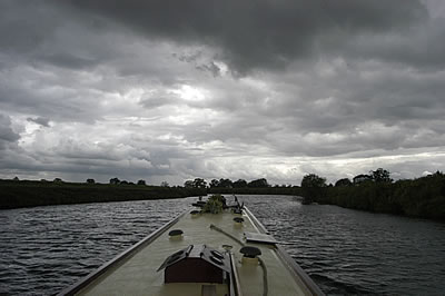 It
is from there the man appeared; his wife was keeping an eye on their
boat. He kindly locked me though Bank Dole and asked me how far I
was going. I told him I was going until I got fed up with it, but
since it was cold and the rain showed no sign of abating I was fed
up with it now! I said I’d probably go on to the next lock,
Beal Lock, and stay there for the night. He told me there were no
moorings as such, but there was a long floating pontoon by way of
a layby berth and that there’d be room to stay there. It
is from there the man appeared; his wife was keeping an eye on their
boat. He kindly locked me though Bank Dole and asked me how far I
was going. I told him I was going until I got fed up with it, but
since it was cold and the rain showed no sign of abating I was fed
up with it now! I said I’d probably go on to the next lock,
Beal Lock, and stay there for the night. He told me there were no
moorings as such, but there was a long floating pontoon by way of
a layby berth and that there’d be room to stay there.
Beyond Bank Dole
Lock the River Aire meanders between steep, inhospitable banks through
fields of sheep. It is not unattractive but it is inhospitable in
that there is nowhere to stop and moor if one needs to. I didn‘t
need to so pressed on for Beal Lock and got there at 4 o’clock.
It was still raining so I tied up on the end of the pontoon and went
below. It had been an interesting day: just over thirteen miles with
four hours underway but a lot of it had been on rivers so I had had
an average speed of 4.2 miles an hour, unheard of on the canals! That
night I wrote in my logbook - 'Great day on river navigation - 1800
rpm, 5.4 mph. Rain, rain, rain. Bloody wet!'
It rained most
of the night and by the next day I convinced myself the river level
was up a bit. It continued to rain through the morning, and whilst
I had to get to Selby that day in order to get through Selby Lock
and onto the River Ouse the following day (something I had had to
book with the lockkeeper there), I decided to wait. I had had a long
day of rain the day before and I was keen to avoid the experience.
Anyway, together with the rest of the nation, perhaps, I was waiting
for news. This was the day that the name of the country to host the
2012 Olympics was to be announced. 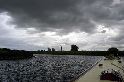 All
eyes were on Singapore, a place I used to live in the early 1980s,
and all ears, well all mine anyway, were tuned to the news bulletins.
The announcement was due just before 1.00 pm. At 12.45 pm Radio Four
went to a special announcement. As they did that my telephone rang.
It was my sister. “London’s got the Olympics!” she
cried. How did she know? With that Radio Four confirmed it! Exciting
stuff. I am not the sort of chap who gets pleasure from other people’s
upset and I got no enjoyment at all from seeing TV pictures from Paris
of their celebration party fading away in disarray, but I was delighted
by the scenes in Trafalgar Square. Bloody good! I got onto the Internet
and signed up to be a volunteer. Whether I will or not is another
thing, but it seems to me that that might be a good way of experiencing
the whole thing. Anyway, as if in celebration of the news it had stopped
raining so I fired up FRILFORD and moved into Beal Lock. The River
Aire thereafter was more of the same: meanderings between steep banks
through fields of sheep – with the cooling towers of Ferrybridge
Power Station ever present astern. It might not have been raining
but the wind was blowing and, as had been the case for days, dark
grey clouds gave solemn relief to the sky. It was a lively time on
the river with FRILFORD moving over the ground, current assisted,
rather quicker than either of us were used to. Over 6.0 miles and
hour at one stage. Heady stuff indeed. All
eyes were on Singapore, a place I used to live in the early 1980s,
and all ears, well all mine anyway, were tuned to the news bulletins.
The announcement was due just before 1.00 pm. At 12.45 pm Radio Four
went to a special announcement. As they did that my telephone rang.
It was my sister. “London’s got the Olympics!” she
cried. How did she know? With that Radio Four confirmed it! Exciting
stuff. I am not the sort of chap who gets pleasure from other people’s
upset and I got no enjoyment at all from seeing TV pictures from Paris
of their celebration party fading away in disarray, but I was delighted
by the scenes in Trafalgar Square. Bloody good! I got onto the Internet
and signed up to be a volunteer. Whether I will or not is another
thing, but it seems to me that that might be a good way of experiencing
the whole thing. Anyway, as if in celebration of the news it had stopped
raining so I fired up FRILFORD and moved into Beal Lock. The River
Aire thereafter was more of the same: meanderings between steep banks
through fields of sheep – with the cooling towers of Ferrybridge
Power Station ever present astern. It might not have been raining
but the wind was blowing and, as had been the case for days, dark
grey clouds gave solemn relief to the sky. It was a lively time on
the river with FRILFORD moving over the ground, current assisted,
rather quicker than either of us were used to. Over 6.0 miles and
hour at one stage. Heady stuff indeed.
After an hour
or so West Haddlesey Flood Lock came into view. This is normally open
so I positioned FRILFORD to turn into it, only to discover it was
closed.  There
was a floating pontoon in the river acting as a layby berth so I had
to reverse FRILFORD against the current and manoeuvre across to it.
It only took a few minutes to work West Haddlesey Flood Lock as the
levels either side were very similar. Indeed I had to work out what
I was supposed to be doing. On the other side I tied up on the layby
berth to sort myself out. I was now off the River Aire and on the
Selby Canal. It started raining again. There
was a floating pontoon in the river acting as a layby berth so I had
to reverse FRILFORD against the current and manoeuvre across to it.
It only took a few minutes to work West Haddlesey Flood Lock as the
levels either side were very similar. Indeed I had to work out what
I was supposed to be doing. On the other side I tied up on the layby
berth to sort myself out. I was now off the River Aire and on the
Selby Canal. It started raining again.
The Selby Canal
is just five miles long, is unencumbered by locks or lift bridges
(there is one swing bridge just before Selby Basin but it is mechanised
and easy to use, albeit one has to stop the traffic in so doing) and
is a complete contrast to the river. It rained for most of my passage
up it, but I enjoyed its rural aspect and wooded banks notwithstanding.
It is a very popular piece of water for fishing and the banks have
many purpose-built stands along the way. As I passed them the few
hardy fishermen who were out stared at me, and I stared back at them.
A few ironic comments passed between us, but otherwise this was a
day for keeping oneself to oneself.
 I
passed through the Selby Swing Bridge just before four o’clock
and was tied up in the Selby Basin by ten past. It was raining hard.
The next day I was to pass through Selby Lock, get out onto the tidal
River Ouse and proceed up to Naburn, where the River Ouse ceases to
be tidal. I went and had a look at the river. It was about half tide.
Brown-grey muddy water flew past the end of the lock filled with every
kind of flotsam and jetsam. Rain passed horizontally across it driven
by gale force winds. And it was cold. It did not look a pleasing prospect.
Was this really July? I
passed through the Selby Swing Bridge just before four o’clock
and was tied up in the Selby Basin by ten past. It was raining hard.
The next day I was to pass through Selby Lock, get out onto the tidal
River Ouse and proceed up to Naburn, where the River Ouse ceases to
be tidal. I went and had a look at the river. It was about half tide.
Brown-grey muddy water flew past the end of the lock filled with every
kind of flotsam and jetsam. Rain passed horizontally across it driven
by gale force winds. And it was cold. It did not look a pleasing prospect.
Was this really July?
The next day I
was due an early start. Because the River Ouse is tidal at Selby the
lockkeeper operates flexible hours, depending on the state of the
tide. I was told to be ready by 8.00 am. Just as I had done the afternoon
before, I went below to the warmth and comfort of FRILFORD’s
saloon and shut out the rest of the day.
Tomorrow was going
to be interesting. Again.

|